Sugar Land, Texas
Mean prices in 2022: all housing units: $483,530; detached houses: $488,934; townhouses or other attached units: $405,366; in 3-to-4-unit structures: $232,004; in 5-or-more-unit structures: $137,419; mobile homes: $188,055
Median gross rent in 2022: $1,788.
March 2022 cost of living index in Sugar Land: 97.1 (near average, U.S. average is 100)
Percentage of residents living in poverty in 2022: 6.5%
(4.3% for White Non-Hispanic residents, 5.1% for Black residents, 4.0% for Hispanic or Latino residents, 28.6% for American Indian residents, 8.7% for other race residents, 5.6% for two or more races residents)

Profiles of local businesses
- Softnix
- Hardcore Concrete Solutions
- The Village at Sugar Land
- All-Pro Sprinklers & Irrigation
- Edgar Garage Door Repair
- Rustic Town Inc
- fittheorem Sugar Land
- We Buy Sugar Land Houses
Put your B&M business profile right here for free. 50,000 businesses already created their profiles!
Compare current foreclosures in Sugar Land, TX:

Sugar Land, TX

Goldenview Park Ln
Sugar Land, TX

Shannondale Dr
Sugar Land, TX

Longhorn Cavern Dr
Sugar Land, TX

Haven Falls Ln
Sugar Land, TX

Riverhollow Ln
Sugar Land, TX

Desert Vine Ct
Sugar Land, TX

Manor Lake Ln
Sugar Land, TX

Oak Lake Point Dr
Sugar Land, TX

Millers Run Ln
Sugar Land, TX

Needle Ridge Ct
Sugar Land, TX

Maple Run Dr
Sugar Land, TX

Foxbrush Ln
Sugar Land, TX

Sugar Sweet Dr
Sugar Land, TX

Sugar Land, TX

Piedmont St
Sugar Land, TX

Hill Spring Dr
Sugar Land, TX

American Elm Ct
Sugar Land, TX

Sugar Land, TX

Summerfield Ridge Ct
Sugar Land, TX

Green Belt Dr
Sugar Land, TX

Arcadia Dr
Sugar Land, TX

Schiller Park Ln
Sugar Land, TX

Bradford Cir
Sugar Land, TX

Calleston Ct
Sugar Land, TX

Tessa Lakes Ct
Sugar Land, TX

Muirwood Ln
Sugar Land, TX

Woodlake Cir
Sugar Land, TX

Palm Royale Blvd
Sugar Land, TX
11,887 sq.ft

1mln listings
from foreclosire.com,
Check out over
Powered by Foreclosure.com
Business Search - 14 Million verified businesses
Loading data.
Based on 2000-2022 data
Loading data.


- 44,386 40.6% White alone
- 37,535 34.3% Asian alone
- 18,095 16.5% Hispanic
- 5,190 4.7% Black alone
- 3,840 3.5% Two or more races
- 247 0.2% Other race alone
- 102 0.09% American Indian alone
According to our research of Texas and other state lists, there were 43 registered sex offenders living in Sugar Land, Texas as of September 09, 2024.
The ratio of all residents to sex offenders in Sugar Land is 2,160 to 1.
The ratio of registered sex offenders to all residents in this city is much lower than the state average.
Type
2009
2010
2011
2012
2013
2014
2015
2016
2017
2018
2019
2020
2021
2022
The City-Data.com crime index weighs serious crimes and violent crimes more heavily. Higher means more crime, U.S. average is 246.1. It adjusts for the number of visitors and daily workers commuting into cities.
- means the value is smaller than the state average.
- means the value is about the same as the state average.
Click on a table row to update graph

Full-time law enforcement employees in 2021, including police officers: 186 (155 officers - 138 male; 17 female).
 Recent articles from our blog. Our writers, many of them Ph.D. graduates or candidates, create easy-to-read articles on a wide variety of topics.
- Popular New Year’s resolutionsDec 31
- Christmas is America’s favorite holiday seasonDec 24
- Fish in the American dish: recreational fishingDec 10
- American hunting and wildlifeNov 19
- The National Football League is an American treasureNov 12
Recent posts about Sugar Land, Texas on our local forum with over 2,400,000 registered users. Sugar Land is mentioned 17,971 times on our forum:
| Proposed Sugar Land Power Plant (0 replies) |
| Sugar Land closing Sprouts (35 replies) |
| Sugar Land to Downtown Commute Borderline Intolerable (9 replies) |
| Sugar Land Going Downhill (13 replies) |
| Feedback on Commonwealth Estates in Sugar Land (4 replies) |
| How is Sugar Land in 77479? (6 replies) |
Latest news from Sugar Land, TX collected exclusively by city-data.com from local newspapers, TV, and radio stations
Ancestries: English (5.2%), American (4.0%), German (3.3%), Irish (2.6%), European (2.0%), Italian (1.6%).
Current Local Time: CST time zone
Land area: 24.1 square miles.
Population density: 4,542 people per square mile (average).
40,199 residents are foreign born (27.2% Asia, 3.7% Latin America).
Median real estate property taxes paid for housing units with mortgages in 2022: $7,393 (1.8%)
Median real estate property taxes paid for housing units with no mortgage in 2022: $6,178 (1.7%)
Nearest city with pop. 200,000+: Houston, TX (17.9 miles , pop. 1,953,631).
Nearest cities:
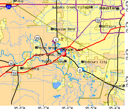
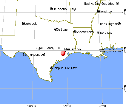
Latitude: 29.60 N, Longitude: 95.61 W
Sugar Land nicknames or aliases (official or unofficial): Sweet Land of Sugar, The next Fort Worth, New Houston
Daytime population change due to commuting: +25,471 (+23.3%)
Workers who live and work in this city: 23,127 (43.0%)
Area codes: 281, 832

Sugar Land tourist attractions:
Single-family new house construction building permits:
- 2022: 136 buildings, average cost: $342,400
- 2021: 151 buildings, average cost: $336,100
- 2020: 148 buildings, average cost: $356,200
- 2019: 124 buildings, average cost: $297,200
- 2018: 141 buildings, average cost: $521,100
- 2017: 158 buildings, average cost: $499,000
- 2016: 162 buildings, average cost: $458,200
- 2015: 143 buildings, average cost: $423,400
- 2014: 175 buildings, average cost: $381,800
- 2013: 162 buildings, average cost: $436,400
- 2012: 395 buildings, average cost: $315,600
- 2011: 371 buildings, average cost: $276,800
- 2010: 437 buildings, average cost: $289,300
- 2009: 424 buildings, average cost: $303,000
- 2008: 478 buildings, average cost: $276,600
- 2007: 500 buildings, average cost: $295,400
- 2006: 502 buildings, average cost: $250,700
- 2005: 182 buildings, average cost: $192,600
- 2004: 242 buildings, average cost: $184,800
- 2003: 292 buildings, average cost: $140,400
- 2002: 271 buildings, average cost: $161,900
- 2001: 228 buildings, average cost: $139,000
- 2000: 265 buildings, average cost: $156,000
- 1999: 351 buildings, average cost: $163,400
- 1998: 249 buildings, average cost: $156,500
- 1997: 195 buildings, average cost: $117,000


Unemployment in December 2023:


Population change in the 1990s: +18,486 (+41.2%).
Most common industries in Sugar Land, TX (%)
- Professional, scientific, technical services (12.6%)
- Health care (10.3%)
- Educational services (9.8%)
- Finance & insurance (6.6%)
- Construction (4.7%)
- Mining, quarrying, oil & gas extraction (4.3%)
- Accommodation & food services (3.5%)
- Professional, scientific, technical services (15.0%)
- Construction (7.0%)
- Mining, quarrying, oil & gas extraction (6.2%)
- Finance & insurance (5.6%)
- Health care (5.6%)
- Educational services (3.8%)
- Accommodation & food services (3.6%)
- Educational services (17.1%)
- Health care (16.1%)
- Professional, scientific, technical services (9.7%)
- Finance & insurance (7.8%)
- Accommodation & food services (3.4%)
- Social assistance (2.8%)
- Real estate & rental & leasing (2.2%)
Most common occupations in Sugar Land, TX (%)
- Other management occupations, except farmers and farm managers (9.0%)
- Computer specialists (5.4%)
- Engineers (5.0%)
- Accountants and auditors (3.8%)
- Registered nurses (3.0%)
- Cooks and food preparation workers (3.0%)
- Secretaries and administrative assistants (2.9%)
- Other management occupations, except farmers and farm managers (9.9%)
- Engineers (8.2%)
- Computer specialists (7.3%)
- Top executives (3.9%)
- Operations specialties managers, except financial managers (2.6%)
- Other health diagnosing and treating practitioners and technical occupations (2.3%)
- Cooks and food preparation workers (2.3%)
- Other management occupations, except farmers and farm managers (7.9%)
- Secretaries and administrative assistants (6.0%)
- Registered nurses (5.7%)
- Accountants and auditors (5.6%)
- Cooks and food preparation workers (3.8%)
- Information and record clerks, except customer service representatives (3.7%)
- Other office and administrative support workers, including supervisors (3.5%)
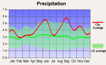
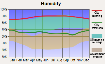
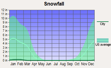
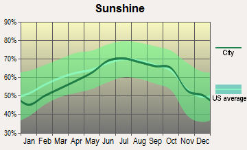
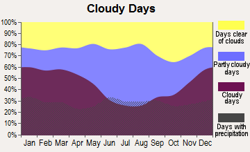
Average climate in Sugar Land, Texas
Based on data reported by over 4,000 weather stations



Air pollution and air quality trends
(lower is better)

Air Quality Index (AQI) level in 2022 was 98.0. This is worse than average.

Carbon Monoxide (CO) [ppm] level in 2014 was 0.247. This is about average. Closest monitor was 17.9 miles away from the city center.

Nitrogen Dioxide (NO2) [ppb] level in 2022 was 8.19. This is significantly worse than average. Closest monitor was 4.5 miles away from the city center.

Sulfur Dioxide (SO2) [ppb] level in 2022 was 0.256. This is significantly better than average. Closest monitor was 4.5 miles away from the city center.

Ozone [ppb] level in 2022 was 24.8. This is better than average. Closest monitor was 8.6 miles away from the city center.

Particulate Matter (PM2.5) [µg/m 3 ] level in 2022 was 8.70. This is about average. Closest monitor was 8.6 miles away from the city center.
Tornado activity:
Sugar Land-area historical tornado activity is slightly above Texas state average. It is 77% greater than the overall U.S. average.
On 11/21/1992, a category F4 (max. wind speeds 207-260 mph) tornado 22.0 miles away from the Sugar Land city center injured 16 people and caused between $50,000,000 and $500,000,000 in damages.
On 9/13/1974, a category F3 (max. wind speeds 158-206 mph) tornado 6.5 miles away from the city center injured 2 people.
Earthquake activity:
Sugar Land-area historical earthquake activity is significantly above Texas state average. It is 37% smaller than the overall U.S. average.
On 10/20/2011 at 12:24:41, a magnitude 4.8 (4.8 MW, Depth: 3.1 mi, Class: Light, Intensity: IV - V) earthquake occurred 157.2 miles away from the city center
On 5/17/2012 at 08:12:00, a magnitude 4.8 (4.8 MW, Depth: 3.1 mi) earthquake occurred 177.1 miles away from Sugar Land center
On 4/9/1993 at 12:29:19, a magnitude 4.3 (4.1 MB, 4.3 LG, Depth: 3.1 mi) earthquake occurred 161.0 miles away from Sugar Land center
On 9/2/2013 at 23:51:15, a magnitude 4.3 (4.3 MW, Depth: 2.9 mi) earthquake occurred 174.6 miles away from Sugar Land center
On 9/2/2013 at 21:52:38, a magnitude 4.2 (4.2 MW, Depth: 3.0 mi) earthquake occurred 176.0 miles away from the city center
On 5/1/2018 at 16:28:56, a magnitude 4.0 (4.0 MW, Depth: 3.1 mi) earthquake occurred 150.9 miles away from Sugar Land center
Magnitude types: regional Lg-wave magnitude (LG), body-wave magnitude (MB), moment magnitude (MW)
Natural disasters:
The number of natural disasters in Fort Bend County (20) is greater than the US average (15).
Major Disasters (Presidential) Declared: 11
Emergencies Declared: 6

Causes of natural disasters: Hurricanes: 9, Storms: 8, Floods: 7, Tornadoes: 3, Fires: 2, Wind: 1, Other: 1 (Note: some incidents may be assigned to more than one category).
Main business address for: NOBLE CORP (DRILLING OIL & GAS WELLS), IMPERIAL SUGAR CO /NEW/ (SUGAR & CONFECTIONERY PRODUCTS), SNB Bancshares Inc (NATIONAL COMMERCIAL BANKS).
Hospitals in Sugar Land:
- CHARTER BEHAVIORAL HLTH SYS/SUGAR LAND (provides emergency services, 1550 FIRST COLONY BLVD)
- EMERUS HOSPITAL (Physician, provides emergency services, 16000 SOUTHWEST FREEWAY)
- MEMORIAL HERMANN SUGAR LAND HOSPITAL (Voluntary non-profit - Private, 17500 W GRAND PARKWAY SOUTH)
- METHODIST SUGAR LAND HOSPITAL (Voluntary non-profit - Church, 16655 SOUTHWEST FREEWAY)
- REGENCY HOSPICE SUGARLAND LTD (9555 WEST SAM HOUSTON PKWY S SUITE 333)
- ST LUKE'S SUGAR LAND HOSPITAL (Voluntary non-profit - Other, 1317 LAKE POINTE PARKWAY)
- SUGAR LAND REHABILITATION HOSPITAL (1325 HIGHWAY 6)
- SUGAR LAND SURGICAL HOSPITAL LLP (Proprietary, 1211 HIGHWAY 6, SUITE 70)
- TRIUMPH HOSPITAL SOUTHWEST (1550 FIRST COLONY BOULEVARD)
Nursing Homes in Sugar Land:
- AUTUMN HILLS CONVALESCENT CENTER (333 MATLAGE WAY)
- SUGAR LAND HEALTH CARE CENTER (333 MATLAGE WAY)
Dialysis Facilities in Sugar Land:
- FIRST COLONY DIALYSIS (1447 HWY 6 SUITE #140)
- SUGARLAND DIALYSIS (13515 SOUTHWEST FREEWAY)
Home Health Centers in Sugar Land:
- A CARE HOME HEALTH SERVICES (19901 SW FRWY SUITE #207)
- ASCON HOME HEALTH SERVICES INC (9507 EMERY HILL DRIVE)
- CHRISTINE HEALTHCARE SERVICES INC (13313 SOUTHWEST FREEWAY SUITE #109)
- CRESCENT HEALTH CARE INC (14905 SOUTHWEST FREEWAY SUITE 209)
- FORTUNE HOME HEALTH INC (13515 SOUTHWEST FRWY SUITE 207)
- KAPPA HOME HEALTH SERVICES INC (11010 RAMP CREEK LANE)
- MARIA REGINA HOME HEALTH AGENCY INC (104 INDUSTRIAL BLVD STE L)
- NEW ESSENCE HEALTH CARE INC (13914 BLUE VISTA DRIVE)
- SERENITY HEALTHCARE SERVICES INC (101 SOUTHWESTERN BEND BLVD SUITE 212)
- SUNLIGHT HOME HEALTH AGENCY INC (13313 SOUTHWEST FREEWAY SUITE 263)
Airports and heliports located in Sugar Land:
- Sugar Land Regional Airport (SGR) (Runways: 1, Air Taxi Ops: 889, Itinerant Ops: 20,784, Local Ops: 21,778, Military Ops: 185)
- Avsi-Sugar Land Heliport (68TA)
- Kaneb Heliport (59TA)
Amtrak station near Sugar Land:
- 19 miles: HOUSTON (902 WASHINGTON AVE.) . Services: ticket office, fully wheelchair accessible, enclosed waiting area, public restrooms, public payphones, vending machines, free short-term parking, free long-term parking, taxi stand, public transit connection.
Local government website: www.sugarlandtx.gov
Colleges/universities with over 2000 students nearest to Sugar Land:
- Houston Baptist University (about 9 miles; Houston, TX; Full-time enrollment: 2,340)
- The Art Institute of Houston (about 14 miles; Houston, TX; FT enrollment: 2,429)
- The University of Texas Health Science Center at Houston (about 15 miles; Houston, TX; FT enrollment: 3,023)
- Rice University (about 16 miles; Houston, TX; FT enrollment: 6,713)
- University of St Thomas (about 17 miles; Houston, TX; FT enrollment: 2,747)
- Houston Community College (about 18 miles; Houston, TX; FT enrollment: 38,303)
- Texas Southern University (about 18 miles; Houston, TX; FT enrollment: 7,053)
Public high schools in Sugar Land:
- CLEMENTS H S (Students: 2,802, Location: 4200 ELKINS DR, Grades: 9-12)
- KEMPNER H S (Students: 2,537, Location: 14777 VOSS RD, Grades: 9-12)
- STEPHEN F AUSTIN H S (Students: 2,351, Location: 3434 PHEASANT CREEK DR, Grades: 9-12)
- DULLES H S (Students: 2,083, Location: 550 DULLES AVE, Grades: 9-12)
- SUGAR LAND MIDDLE (Students: 1,412, Location: 321 SEVENTH ST, Grades: 6-9)
- DULLES MIDDLE (Students: 1,342, Location: 500 DULLES AVE, Grades: 6-9)
- M R WOOD CENTER FOR LEARNING (Students: 97, Location: 138 AVE F, Grades: 2-12)
- HARMONY SCHOOL OF SCIENCE - HOUSTON HIGH (Location: 13522 W AIRPORT BLVD, Grades: 7-12, Charter school)
Private high schools in Sugar Land:
- FORT BEND CHRISTIAN ACADEMY (Students: 783, Location: 1250 7TH ST, Grades: PK-12)
- TRENT INTERNATIONAL SCHOOL (Students: 159, Location: 2555 CORDES DR, Grades: PK-12)
Biggest public elementary/middle schools in Sugar Land:
- MACARIO GARCIA MIDDLE (Students: 1,360, Location: 18550 OLD RICHMOND RD, Grades: 6-8)
- SARTARTIA MIDDLE (Students: 1,269, Location: 8125 HOMEWARD WAY, Grades: 6-8)
- FIRST COLONY MIDDLE (Students: 1,117, Location: 3225 AUSTIN PKWY, Grades: 6-8)
- FORT SETTLEMENT MIDDLE (Students: 1,095, Location: 5440 ELKINS RD, Grades: 6-8)
- WALKER STATION EL (Students: 903, Location: 6200 HOMEWARD WAY BLVD, Grades: PK-5)
- BARRINGTON PLACE EL (Students: 877, Location: 2100 SQUIRE DOBBINS DR, Grades: PK-5)
- TOWNEWEST EL (Students: 840, Location: 13927 OLD RICHMOND RD, Grades: PK-5)
- OYSTER CREEK EL (Students: 824, Location: 16425 MELLOW OAKS LN, Grades: KG-5)
- AUSTIN PARKWAY EL (Students: 819, Location: 4400 AUSTIN PKWY, Grades: PK-5)
- BRAZOS BEND EL (Students: 780, Location: 621 CUNNINGHAM CREEK BLVD, Grades: PK-5)
Biggest private elementary/middle schools in Sugar Land:
- THE HONOR ROLL SCHOOL (Students: 874, Location: 4111 SWEETWATER BLVD, Grades: UG-8)
- ST LAURENCE CATHOLIC SCHOOL (Students: 707, Location: 2630 AUSTIN PKWY, Grades: PK-8)
- CORNERSTONE CHRISTIAN ACADEMY (Students: 408, Location: 2140 FIRST COLONY BLVD, Grades: PK-8)
- THE WALDEN SCHOOL (Students: 141, Location: 16103 LEXINGTON BLVD A, Grades: PK-2)
- ST THERESA CATHOLIC SCHOOL (Students: 108, Location: 705 ST THERESA BLVD, Grades: PK-3)
- RIVERBEND MONTESSORI SCHOOL (Students: 100, Location: 4225 ELKINS RD, Grades: PK-6)
- FELLOWSHIP CHRISTIAN ACADEMY (Students: 86, Location: 16425A OLD RICHMOND RD, Grades: PK-7)
- FAITH LUTHERAN SCHOOL (Students: 48, Location: 800 BROOKS ST, Grades: PK-5)
- CAMBRIDGE MONTESSORI SCHOOL (Students: 39, Location: 6380 HIGHWAY 90A, Grades: PK-2)
- GOD'S RAINBOW CHRISTIAN ACADEMY (Students: 21, Location: 13131 ALSTON RD, Grades: UG-6)
User-submitted facts and corrections:
- Please include the new school in sugar land, TX 77479. Name is Brazos Montessori, address 4022 Angel Springs Lane, Sugar Land, TX 77479. Phone 281-980-9830. Website: http//www.freewebs.com/brazosmontessori.
Points of interest:
Notable locations in Sugar Land: Riverbend Country Club (A) , Market at Town Center (B) , Sugar Land Fire Department Station 1 (C) , Sugar Land Fire Department Station 2 (D) , Sugar Land Fire Department Station 3 (E) , Sugar Land Fire Department Station 4 (F) , Sugar Land Fire Department Chief / Administrative Offices (G) , Sugar Land Police Department (H) , Sugar Land Community Center (I) , City of Sugar Land Fire Department (J) , Fire Station Number 3 (K) , Fire Station Number 4 (L) . Display/hide their locations on the map
Shopping Centers: Williams Trace Shopping Center (1) , First Colony Commons Shopping Center (2) , First Colony Shopping Center (3) , Austin Parkway Shopping Center (4) , Market at First Colony Shopping Center (5) , Sweetwater Plaza Shopping Center (6) . Display/hide their locations on the map
Main business address in Sugar Land include: NOBLE CORP (A) , IMPERIAL SUGAR CO /NEW/ (B) , SNB Bancshares Inc (C) . Display/hide their locations on the map
Churches in Sugar Land include: Holy Cross Episcopal Church (A) , All Saints Episcopal Church (B) , Sugar Land Church of God (C) , Redeemed Christian Church of God Jesus House (D) , First Colony Church of Christ Youth Ministry (E) , Eldridge Road Church of Christ (F) , Williams Trace Baptist Church (G) , Trinity Baptist Church (H) , Sugar Creek Baptist Church (I) . Display/hide their locations on the map
Lakes and reservoirs: Alkire Lake (A) , Venetian Lake (B) , Horseshoe Lake (C) , Cleveland Lake (D) , Char Lake (E) , Brooks Lake (F) , Eldridge Lake (G) , Brooks, Cleveland and Char Lakes (H) . Display/hide their locations on the map
Streams, rivers, and creeks: Bullhead Bayou (A) , Browns Bayou (B) . Display/hide their locations on the map
Parks in Sugar Land include: Ron Slockett Park (1) , Sugar Mill Park (2) , Aerodrome - Sugar Land (3) , Dulles High School Practice Stadium (4) , Edward Mercer Stadium (5) , Fort Bend Independent School District Baseball Field (6) . Display/hide their locations on the map
Tourist attractions: Fort Bend County Offices - Libraries- Mamie George (Cultural Attractions- Events- & Facilities; 320 Dulles Avenue) (1) , Fort Bend County - Switchboard- County Judge James Adolphus- Bob Lutts Fulshear Simonton Br (Cultural Attractions- Events- & Facilities; 2121 Austin Parkway) (2) , Aerodrome Ice Skating Complexes - Sugar Land (Amusement & Theme Parks; 16225 Lexington Boulevard) (3) , Amf Bowling Centers (Amusement & Theme Parks; 4919 South Main) (4) . Display/hide their approximate locations on the map
Courts: Texas Department Of Criminal Justice (2020 Imogene Road) (1) , Texas State - Texas Department of Criminal Justice- Institutional Division- Central (Highway 90 A) (2) . Display/hide their approximate locations on the map
Birthplace of: Brittney Karbowski - Voice actor, Ethan Kelley - 2005 NFL player (Cleveland Browns, born: Feb 12, 1980), Vanessa Olivarez - Singer, Aaron Coombs - College basketball player (NC Wilmington Seahawks), Antoine Hood - College basketball player (Air Force Falcons), Elliot Coffey - College Football player, Kendrick Davis - College basketball player (North Texas Eagles), Kenny Taylor - College basketball player (Texas Longhorns).
Fort Bend County has a predicted average indoor radon screening level less than 2 pCi/L (pico curies per liter) - Low Potential
Drinking water stations with addresses in Sugar Land and their reported violations in the past:
SONIC ALDINE (Population served: 500, Groundwater):
- Monitoring, Source Water (GWR) - In FEB-01-2012, Contaminant: E. COLI. Follow-up actions: St Violation/Reminder Notice (MAR-26-2012), St Public Notif requested (MAR-26-2012)
CRABB RIVER ROAD EXXON (Population served: 500, Groundwater):
- One routine major monitoring violation
PNJ FOOD MART (Population served: 250, Groundwater):
- 4 routine major monitoring violations
HANDI PLUS 69 (Population served: 200, Groundwater):
- Monitoring, Source Water (GWR) - In JAN-01-2011, Contaminant: E. COLI. Follow-up actions: St Violation/Reminder Notice (MAR-02-2011), St Public Notif requested (MAR-02-2011)
- 5 routine major monitoring violations
HANDI STOP 89 (Population served: 200, Groundwater):
- 4 routine major monitoring violations
PECAN CREEK (Population served: 200, Groundwater):
- 2 routine major monitoring violations
- One minor monitoring violation
HANDI STOP 22 (Population served: 200, Groundwater):
- Monitoring, Source Water (GWR) - In OCT-01-2011, Contaminant: E. COLI. Follow-up actions: St Public Notif requested (DEC-09-2011), St Violation/Reminder Notice (DEC-09-2011), St Public Notif received (MAY-29-2012)
HANDI STOP 18 TEXACO (Population served: 150, Groundwater):
- MCL, Monthly (TCR) - In JUL-2011, Contaminant: Coliform. Follow-up actions: St Violation/Reminder Notice (JUL-26-2011), St Public Notif requested (JUL-26-2011)
- Monitoring, Source Water (GWR) - In JUL-01-2011, Contaminant: E. COLI. Follow-up actions: St Violation/Reminder Notice (AUG-25-2011), St Public Notif requested (AUG-25-2011)
- One routine major monitoring violation
Drinking water stations with addresses in Sugar Land that have no violations reported:
- KEP FOOD STORE #2 (Population served: 275,Primary Water Source Type: Groundwater)
- MASTERS VESSEL MINISTRIES (Population served: 200,Primary Water Source Type: Groundwater)
- COUNTRY VILLAGE (Population served: 150,Primary Water Source Type: Groundwater)
- SHILOH RV PARK (Population served: 101,Primary Water Source Type: Groundwater)
- JMLR INTERESTS (Population served: 35,Primary Water Source Type: Groundwater)
Average household size:
Percentage of family households:
Percentage of households with unmarried partners:
- Lesbian couples: 0.3% of all households
- Gay men: 0.3% of all households
People in group quarters in Sugar Land in 2010:
- 932 people in federal prisons
- 313 people in nursing facilities/skilled-nursing facilities
- 86 people in emergency and transitional shelters (with sleeping facilities) for people experiencing homelessness
- 71 people in workers' group living quarters and job corps centers
- 7 people in other noninstitutional facilities
- 4 people in residential treatment centers for adults
People in group quarters in Sugar Land in 2000:
- 270 people in nursing homes
- 157 people in other noninstitutional group quarters
- 58 people in other group homes
- 6 people in religious group quarters
Banks with most branches in Sugar Land (2011 data):
- JPMorgan Chase Bank, National Association: 9 branches. Info updated 2011/11/10: Bank assets: $1,811,678.0 mil, Deposits: $1,190,738.0 mil, headquarters in Columbus, OH, positive income, International Specialization, 5577 total offices, Holding Company: Jpmorgan Chase & Co.
- Wells Fargo Bank, National Association: 7 branches. Info updated 2011/04/05: Bank assets: $1,161,490.0 mil, Deposits: $905,653.0 mil, headquarters in Sioux Falls, SD, positive income, 6395 total offices, Holding Company: Wells Fargo & Company
- BOKF, National Association: Sweetwater Branch, Sugar Land Branch, 1st Colony Branch. Info updated 2012/02/28: Bank assets: $25,360.0 mil, Deposits: $19,171.3 mil, headquarters in Tulsa, OK, positive income, Commercial Lending Specialization, 189 total offices, Holding Company: Bok Financial Corporation
- First Community Bank, National Association: Granite Towers Lpo, First Colony Branch, at 13135 Dairy Ashford, Suite 175. Info updated 2009/03/24: Bank assets: $634.7 mil, Deposits: $559.1 mil, local headquarters, negative income in the last year, Commercial Lending Specialization, 33 total offices, Holding Company: Jll/Fch Holdings I, Llc
- Compass Bank: First Colony Branch, Sugarcreek Branch, Sugar Land Branch. Info updated 2011/02/24: Bank assets: $63,107.0 mil, Deposits: $46,232.4 mil, headquarters in Birmingham, AL, negative income in the last year, Commercial Lending Specialization, 720 total offices, Holding Company: Banco Bilbao Vizcaya Argentaria, S.A.
- MetroBank, National Association: William Trace Branch at 15144 Southwest Freeway, branch established on 1995/11/06; Dulles Branch at 4635 Highway 6, branch established on 1999/03/12. Info updated 2006/11/03: Bank assets: $1,103.1 mil, Deposits: $932.8 mil, headquarters in Houston, TX, positive income, Commercial Lending Specialization, 14 total offices, Holding Company: Metrocorp Bancshares, Inc.
- Comerica Bank: Sugar Creek Branch at One Sugar Creek Center Boulevard, branch established on 1977/06/01; Fluor Daniel Dr-Highway 6 Branch at 1525 Highway 6, branch established on 2005/12/29. Info updated 2011/07/29: Bank assets: $60,970.5 mil, Deposits: $48,300.9 mil, headquarters in Dallas, TX, positive income, Commercial Lending Specialization, 497 total offices, Holding Company: Comerica Incorporated
- Prosperity Bank: First Colony Branch at 1735 Lake Point Parkway, branch established on 2006/12/11; Sugar Land Branch at 14060 Southwest Freeway, branch established on 1985/01/14. Info updated 2012/01/05: Bank assets: $9,816.2 mil, Deposits: $8,064.8 mil, headquarters in El Campo, TX, positive income, Mortgage Lending Specialization, 187 total offices, Holding Company: Prosperity Bancshares, Inc.
- International Bank of Commerce: In-Store W. Airport Branch at 1565 State Hwy 6 S., branch established on 2001/02/28; Woodbridge - W. Bellfort Branch at 10570 State Hwy. 6, branch established on 2004/10/12. Info updated 2007/03/28: Bank assets: $9,621.9 mil, Deposits: $6,548.8 mil, headquarters in Laredo, TX, positive income, Commercial Lending Specialization, 197 total offices, Holding Company: International Bancshares Corporation
- 19 other banks with 22 local branches
For population 15 years and over in Sugar Land:

- Never married: 23.9%
- Now married: 65.4%
- Separated: 1.5%
- Widowed: 3.2%
- Divorced: 6.1%
For population 25 years and over in Sugar Land:
- High school or higher: 95.8%
- Bachelor's degree or higher: 65.4%
- Graduate or professional degree: 30.0%
- Unemployed: 3.9%
- Mean travel time to work (commute): 19.8 minutes


![]()


 Recent articles from our blog. Our writers, many of them Ph.D. graduates or candidates, create easy-to-read articles on a wide variety of topics.


